Guidance Mode allows you to quickly follow utility paths
Guidance Mode allows you to rapidly find and follow the path of a buried utility. Directional information is displayed alongside proportional distance arrows to help find the utility and then keep you on its path. The simultaneous display of depth and current information gives confidence the correct utility is being traced even in congested networks. For rough or uneven terrain differentiated audio tones can be used, freeing the user to concentrate on potential hazards.
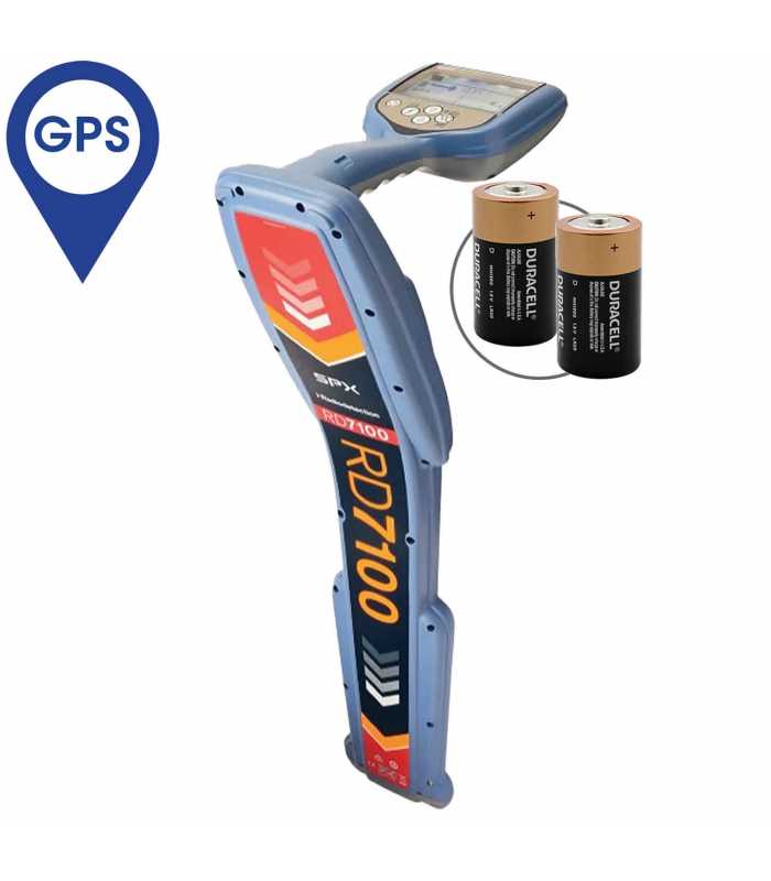
Automatic usage-logging with GPS positioning
GPS equipped RD7100 locators automatically capture key locate parameters every second, providing a comprehensive picture of individual locates and allowing you to assess usage patterns over periods of a year or more.
The data generated can be used to ensure adherence to best practice, or to identify training needs before poor work habits develop. Additionally, the information can be used for internal audits or shared with stakeholders to enable process improvements, and evidence task completion.
Usage data can be exported in multiple file formats – for example, KML for Google Maps to confirm where and when the work was performed.
Li-Ion rechargeable battery options
Lithium-Ion rechargeable battery options for both locator and transmitter provide extended runtime with reduced running costs.
Peak+™ Mode combines accuracy with speed
Combine the accuracy of Peak locating with the rapid ground coverage of Guidance arrows in the new Peak+™ mode. A single key press lets you check for distortion by comparing Null with Peak.
Power Filters™ pinpoint and discriminate between power cables (PL models)
When a signal transmitter can’t be connected, tracing individual power lines through complex networks can be a real challenge. Conflicting or powerful signals confuse, or combine to create a wash of signal.
With a single key press you can now utilize the harmonic properties of power signals to establish if a signal comes from one source, or from multiple cables, then trace and mark their routes.
RD Map™ app
RD Map™ uses Bluetooth to create, in real time*, detailed maps of buried utilities: each survey measurement parameter is appended to the GPS positional information obtained by the locator, external or Android device to map the route of the tracked utility. Map files (CSV or KML) can then be shared via e-mail or any compatible messaging system.
* Requires data connectivity and availability of Google Maps.
![SPX Radiodetection RD7100DLG [10/71DLG] Precision Cable & Pipe Locator Receiver with GPS](https://indomultimeter.com/image/cache/catalog/Products/Radiodetection_RD7100DLG-1500x1500.jpg "SPX Radiodetection RD7100DLG [10/71DLG] Precision Cable & Pipe Locator Receiver with GPS")
![SPX Radiodetection RD7100DLG [10/71DLG] Precision Cable & Pipe Locator Receiver with GPS](https://indomultimeter.com/image/cache/catalog/Products/Radiodetection_RD7100-3-1500x1500.jpg "SPX Radiodetection RD7100DLG [10/71DLG] Precision Cable & Pipe Locator Receiver with GPS")
![SPX Radiodetection RD7100DLG [10/71DLG] Precision Cable & Pipe Locator Receiver with GPS](https://indomultimeter.com/image/cache/catalog/Products/Radiodetection_RD7100-2-1500x1500.jpg "SPX Radiodetection RD7100DLG [10/71DLG] Precision Cable & Pipe Locator Receiver with GPS")
![SPX Radiodetection RD7100DLG [10/71DLG] Precision Cable & Pipe Locator Receiver with GPS](https://indomultimeter.com/image/cache/catalog/Products/Radiodetection_RD7100-4-1500x1500.jpg "SPX Radiodetection RD7100DLG [10/71DLG] Precision Cable & Pipe Locator Receiver with GPS")
![SPX Radiodetection RD7100DLG [10/71DLG] Precision Cable & Pipe Locator Receiver with GPS](https://indomultimeter.com/image/cache/catalog/Products/Radiodetection_RD7100-5-1500x1500.jpg "SPX Radiodetection RD7100DLG [10/71DLG] Precision Cable & Pipe Locator Receiver with GPS")
![SPX Radiodetection [10/SONDE-STD-8] Standard Sonde 8kHz](https://indomultimeter.com/image/cache/catalog/Products/Radiodetection_10SONDE-STD-8-250x250.jpg)


![SPX Radiodetection Tx-5 [10/RDTX5] Multifunction Signal Transmitter](https://indomultimeter.com/image/cache/catalog/Products/Radiodetection_TX-5-250x250.jpg)
![SPX Radiodetection Tx-5 [10/RDTX5] Multifunction Signal Transmitter](https://indomultimeter.com/image/cache/catalog/Products/Radiodetection_TX-Acc-250x250.jpg)
![SPX Radiodetection Tx-5 iLOC [10/RDTX5B] Multifunction Signal Transmitter w/ iLOC](https://indomultimeter.com/image/cache/catalog/Products/Radiodetection_10RDTX5B-250x250.jpg)
![SPX Radiodetection Tx-1 [10/RDTX1] Transmitter](https://indomultimeter.com/image/cache/catalog/Products/Radiodetection_TX-1-250x250.jpg)
![SPX Radiodetection Tx-10 [10/RDTX10] Multifunction Signal Transmitter](https://indomultimeter.com/image/cache/catalog/Products/Radiodetection_TX-10-250x250.jpg)
![SPX Radiodetection [10/TX-CLAMP-50] 2 Inch (50mm) Transmitter Clamp](https://indomultimeter.com/image/cache/catalog/Products/Radiodetection_10-TX-CLAMP-100-250x250.jpg)
![SPX Radiodetection 10RXSTETHOSCOPEHG [10/RX-STETHOSCOPE-HG] High Gain Stethoscope](https://indomultimeter.com/image/cache/catalog/Products/Radiodetection_10-RX-STETHOSCOPE-HG-250x250.jpg)
![SPX Radiodetection 10RXCDCLAMP [10/RX-CD-CLAMP] Locator CD/CM Clamp](https://indomultimeter.com/image/cache/catalog/Products/Radiodetection_10-RX-CD-CLAMP-250x250.jpg)
![SPX Radiodetection [10/RX-STETHOSCOPE-L] Large Stethoscope](https://indomultimeter.com/image/cache/catalog/Products/Radiodetection_10-RX-STETHOSCOPE-L-250x250.jpg)
![SPX Radiodetection [10/RX-STETHOSCOPE-S] Small Stethoscope](https://indomultimeter.com/image/cache/catalog/Products/Radiodetection_10-RX-STETHOSCOPE-S-250x250.jpg)
![SPX Radiodetection 10RXCLAMP50 [10/RX-CLAMP-50] 2 Inch (50mm) Receiver Clamp](https://indomultimeter.com/image/cache/catalog/Products/Radiodetection_10-RX-CLAMP-50-250x250.jpg)
![SPX Radiodetection [10/GG1540-LPC] Live Plug Connector (LPC)](https://indomultimeter.com/image/cache/catalog/Products/Radiodetection_10-GG1540-LPC-250x250.jpg)
![SPX Radiodetection Tx-5 [10/RDTX5-R] Multifunction Signal Transmitter w/ Li-Ion Rechargeable Battery Pack](https://indomultimeter.com/image/cache/catalog/Products/Radiodetection_10RDTX5R-250x250.jpg)
![SPX Radiodetection Tx-5 iLOC [10/RDTX5B-R] Multifunction Signal Transmitter w/ iLOC & Li-Ion Rechargeable Battery](https://indomultimeter.com/image/cache/catalog/Products/Radiodetection_10RDTX5BR-250x250.jpg)
![SPX Radiodetection Tx-10 [10/RDTX10-R] Multifunction Signal Transmitter w/ Li-Ion Rechargeable Battery](https://indomultimeter.com/image/cache/catalog/Products/Radiodetection_10RDTX10R-250x250.jpg)
![SPX Radiodetection Tx-10 [10/RDTX10B] Multifunction Signal Transmitter w/ iLOC](https://indomultimeter.com/image/cache/catalog/Products/Radiodetection_10RDTX10B-250x250.jpg)
![SPX Radiodetection Tx-10 [10/RDTX10B-R] Multifunction Signal Transmitter w/ iLOC & Li-Ion Rechargeable Battery](https://indomultimeter.com/image/cache/catalog/Products/Radiodetection_10RDTX10BR-250x250.jpg)


![SPX Radiodetection 10RXCLAMP130 [10/RX-CLAMP-130] 5 inch (130mm) Receiver Clamp](https://indomultimeter.com/image/cache/catalog/Products/Radiodetection_10-RX-CLAMP-130-250x250.jpg)
![SPX Radiodetection 10RXCLAMP215 [10/RX-CLAMP-215] 8 Inch (215mm) Receiver Clamp](https://indomultimeter.com/image/cache/catalog/Products/Radiodetection_10-TX-CLAMP-215-250x250.jpg)
![SPX Radiodetection 10TXCLAMPEXTROD [10/TX-CLAMP-EXTROD] Signal Clamp Extension Rod](https://indomultimeter.com/image/cache/catalog/Products/Radiodetection_10TX-CLAMP-EXTROD-250x250.jpg)


